Databasing Mosses and Lichens
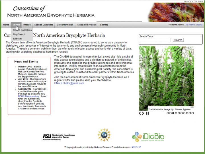
The Symbiota Portals
The specimen records for the OSU Herbarium (OS) are maintained and managed as “live” data sets on their respective Symbiota “portals.” For bryophytes it is CNABH (Consortium of North American Bryophyte Herbaria) and for lichens, CNALH. In addition to providing user-friendly software tools for entering and modifying data, the portals make the records accessible to the internet community. For example HERE (link) is a recent moss record from Hocking County. Notice that in addition to all pertinent data such as catalog number, species, date, collector, location, etc, .i.e., everything that is on the specimen label in our herbarium, there is an image (photo of the moss in the field; not many records will have this though) and a “map” tab that shows the exact collection location on a map. The reason that there is a “map” tab is that there are latitude and longitude geo-reference data in specific fields on the CNABH collection management page for that record (more about that later). A benefit of having that geo-reference data filled in is that, when someone does an internet search for a particular species, they will see a dot on the map that shows that we have it. NOTE: Many herbarium records on the portal are nearly complete, with all the pertinent information about the specimen that is on the actual label, but without the geo-reference fields filled in. These don’t show up on the map, and some users might not know to look at search results that can be obtained using the portal, rather than only the map, and so will mistakenly think there are fewer or no OS records!
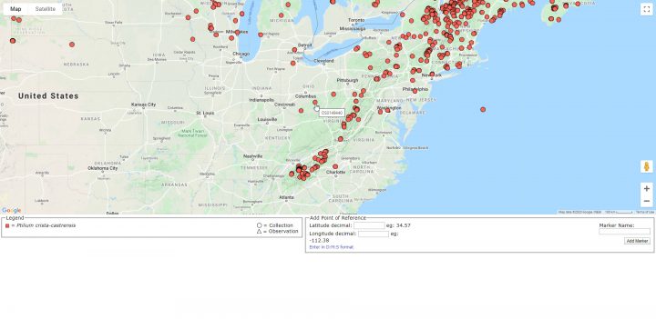
Screen capture of CNABH map for Ptilium crista-castrensis.
When these two cryptogam portals were set up, it was decided to image not the specimens like they do for the vascular plants, but just the packets with the collection data visible on them. The high-throughput initial effort produced “skeletal” records consisting of only the packet photo and the scientific name. HERE (link) is an example of a “skeletal” record for a lichen. Notice how there is abundant information on the packet but essentially none except for species and catalog number showing on the page itself.
For convenience, we have 4 categories of record completeness in curating the OS specimens” They are:
- “Skeletal” (unprocessed) records are the most rudimentary, consisting only of the label and species, sometimes along with a couple/few fields that were easy to enter along with the initial record creation.
- “Stage 1” records have COLLECTION DATE, and COUNTY (including of course county and state).
- “Stage 2” is all the information on the label EXCEPT geo-reference data in the mapping fields.
- “Stage 3” adds the geo-reference data.
Current Status and Goals
OS Bryophytes and Lichens Collections
I. Bryophytes
Status: Presently, for bryophytes (CNABH) we have approximately:
- 0 “skeletal/unprocesed” records, thanks to a tremendous effort by Jim Toppin, a very active volunteer working from his home in Port Clinton.
- 15,000 “Stage 1” records (that Jim produced from the formerly skeletal ones)
- 0 “Stage 2”
- 700 “Stage 3” records (mostly new specimens added since we started using the portal)
Goals: Essentially all of our bryophyte specimens are on the portal (none remain to be imaged or entered for the first time). We’d like to have better than “Stage 1” representation of all Ohio counties for each species, so that they would be apparent to visitors to the portal. The plan is to select one or a few nice modern records for each species for each county, and bring them up to “Stage 3.”
II. Lichens
Status: Presently for lichens (CNALH) we have approximately:
- 11,000 unprocessed ones
- 5000 “Stage 1” records
- 400 “Stage 2” records
- 300 “Stage 3” records.
Goals: There are a few thousand packets yet to be imaged. They are in the cabinets with sticky notes saying they need barcodes. Eventually they need to be entered, but that’s can;t be done remotely, so forget that for now.
The “unprocessed/skeletal” records need to be brought up to “Stage 1.”
[There’s also the Rudolph collection of Antarctic lichens, a unique subset of the collection that is of higher priority than the others because of researcher interest. There are about 500 of them that have been imaged but not yet uploaded, but they soon will be, as “unprocessed/skeletal” records (and about 1500 more unidentified ones in the cabinets eager to be looked at). More on this later.]
Working in a Portal
(moss example)
- Log on to the CNABH using your username and PW.
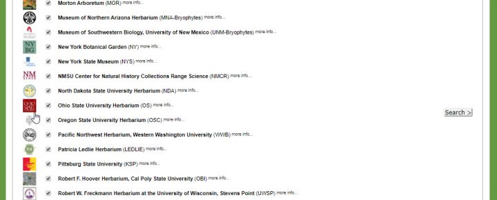
- In the upper left, go to “SEARCH” -> “COLLECTIONS”
- Select the OS collection.
- Notice that there is a little pen or pencil in the upper right corner. That’s the “editing” tab, only displayed for specimens or collections that you have editing privileges for.

- “Edit existing occurrence records”
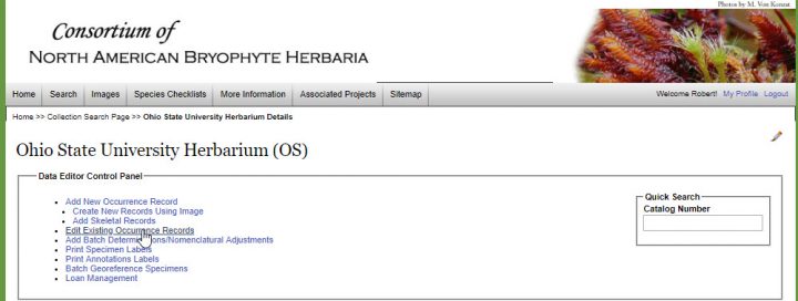
- Search and sort in a manner than will help you pick specimens to upgrade from “Stage 1” to “Stage 3.” Pick the species you want to upgrade records for by entering that name EQUALS the “Custom Field 1” space. A list of Ohio mosses cane be found HERE (link) in the Ohio Moss and Lichen Association web site. Then add another Custom Field and go for “State/Province” EQUALS “Ohio.” Select “Table View” Sort by “County.” Pick the best looking (most recent and well documented, especially for geolocation data –latitude and longitude either there on the label or able to be figured out using Google Maps) one for each county we have that species from and upgrade each to “Stage 3.” (You’ll be able to run through the list without complicated navigating by pressing the >> link to the next record in the sorted list when you are in an editing panel.)
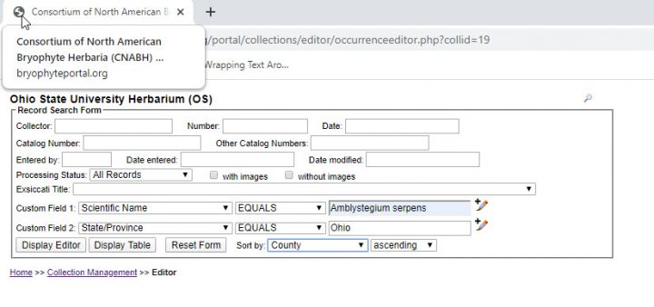
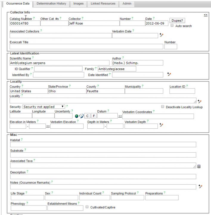
- Open in a new window and you see the fields that can be filled in.Here it is before:
 …and here is is after:
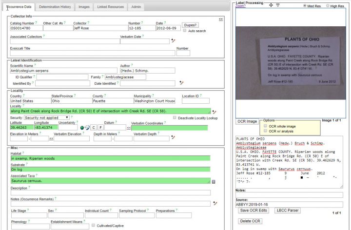 Notice that there’s an OCR utility called the “LBCC Parser.” If the OCR below the image looks OK, then try pressing that button; it will populate fields, sometimes with remarkable accuracy. Otherwise, and in addition, fill in the fields freehand. The latitude and longitude data are a bit tricky. Google Maps is your friend. So-called “Verbatim Coordinates” are degrees minutes and seconds like what show up if you choose “what’s here” when you’re in Google Maps, and get a display like this:
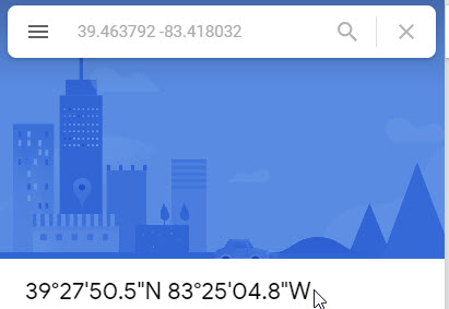 Pasting that into the “Verbatin Coordinates” and then clicking those double arrows immediately to the left of the now filled-in “Verbatim Coordinates” field will populate the all-important Latitude and Longitide geo-reference fields, so that the record will be mapped. Also, notice that there are two links to two online tools for finding coordinates. One (the world symbol) works with Google Maps, and the other (the swoosh-like symbol) uses the text in the “Locality” field to figure out where you are. Experiment with these to see how they work.
 - Once all the fields are filled in, change the processing status to “Stage 3″and be sure to “save edits.”
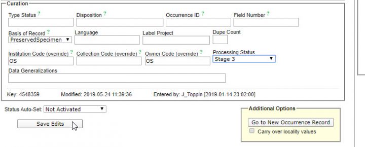 Also please make sure that “Status Auto-Set” is Not Activated, so that the record stays as “Stage 3.”HERE (link) is what the record looks like on the portal. Nice, eh?
 - Next, pick a different county. We’ll have to come up with a way to keep track of what needs to be done. That and other details can be worked out. Questions? Contact Bob at klips.1. Happy databasing!